

Open User Map
Discover how Open User Map turns your WordPress site into a living, community-driven map where visitors add locations with zero coding or API keys.
About Open User Map
Open User Map is a powerful, interactive mapping plugin designed specifically for WordPress that transforms how you and your visitors engage with geographic data. At its core, this tool allows anyone visiting your website to contribute locations directly to a map through a simple frontend submission process, making it a truly collaborative mapping experience. What makes Open User Map particularly intriguing is its commitment to simplicity and accessibility: there is absolutely no coding required, no need for a Google Maps API key, and no complex setup procedures that typically bog down similar tools. This plugin is built for website owners, community managers, local business directories, tourism boards, event organizers, and anyone who wants to create a dynamic, user-driven map without technical headaches. The main value proposition revolves around democratizing map data collection while maintaining full editorial control through approval workflows. You can customize nearly every aspect of the map experience, from marker icons and categories to custom fields and filtering options, all within a familiar WordPress environment. With over 15,000 active installs, a perfect 5-star rating, and recognition as the number two map plugin on WordPress.org, Open User Map has proven itself as a reliable, feature-rich solution that balances powerful functionality with an intuitive user experience. Whether you are building a community resource map, a local business directory, or an interactive event guide, this plugin invites you to explore new ways of connecting people with places.
Features of Open User Map
Frontend Location Submissions and Editing
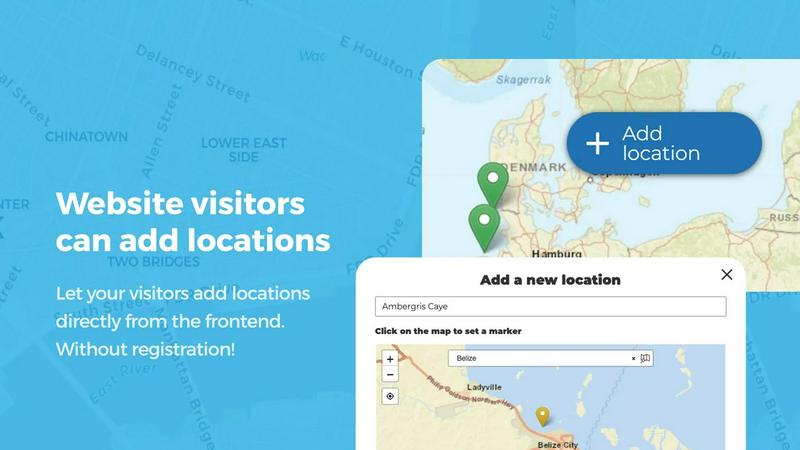
This feature empowers your website visitors to add and edit locations directly from the map interface without needing any backend access. When a user clicks the Add location button, they can place a marker on the map, fill out details such as name, description, and custom fields, and submit the entry for your approval. The editing capability is equally powerful, allowing users to return and update their existing submissions, ensuring the map always reflects the most current and accurate information. This two-way interaction fosters a sense of community ownership and keeps your map data fresh and relevant.
Marker Categories and Advanced Filtering
Organizing your map becomes effortless with the ability to group locations into distinct marker categories, each featuring its own unique icon for instant visual recognition. This categorization not only declutters the map but also enables visitors to filter through different types of locations, such as restaurants, parks, or historical sites, with a single click. A particularly flexible aspect is that each location can belong to multiple categories, ensuring that a coffee shop that also hosts live music can be found under both relevant filters, making the map more intuitive and useful for everyone exploring it.
Lines and Areas for Routes and Zones
Open User Map goes beyond simple point markers by allowing you to draw lines, paths, zones, and regions directly onto your map. This feature is perfect for highlighting hiking trails, service delivery areas, event grounds, neighborhood boundaries, construction zones, or any custom shape that adds context to your map. Distances and area sizes are calculated automatically, so routes and polygons include helpful measurements right out of the box, giving visitors a richer understanding of spatial relationships without any manual calculations.
Custom Image as Map
This innovative feature lets you upload any image and transform it into a fully interactive map, opening up a world of possibilities beyond traditional geography. Whether you need an overlay for a floor plan, an event layout, a game map, a product diagram, a campus guide, or a seating chart, you can place markers directly on top of the image with the same powerful functionality as a standard map. Users can add locations, display custom fields, enable filtering, and create an engaging, clickable experience tailored exactly to your specific use case, making it ideal for indoor spaces or conceptual diagrams.
Use Cases of Open User Map
Community Resource and Event Mapping
Local community groups and neighborhood associations can use Open User Map to create a living directory of resources, such as community gardens, free libraries, public art installations, and upcoming events. Residents can submit new locations and update existing ones, ensuring the map remains a current and valuable tool for everyone. The approval workflow ensures that only accurate and appropriate information goes live, while the filtering capabilities allow users to quickly find exactly what they need, fostering a stronger, more connected community.
Local Business and Service Directories
Business associations and tourism boards can build a comprehensive, user-driven directory of local shops, restaurants, services, and attractions. Business owners can add their own listings with details like hours of operation, contact information, and special offers, while visitors can upvote or rate locations to highlight the best spots. The opening hours feature with a live Open Now indicator makes this especially useful for people looking for currently available services, turning the map into a dynamic, real-time resource for both locals and tourists.
Event Venue and Campus Navigation
Event organizers and university administrators can deploy Open User Map to help attendees navigate complex venues or sprawling campuses. By using the Custom Image as Map feature, you can upload a floor plan of a convention center or a campus map and place markers for specific booths, lecture halls, restrooms, food courts, and information desks. Visitors can add their own markers for meetup points or lost and found items, and the filtering system helps them quickly find sessions or amenities relevant to their interests.
Tourism and Travel Guides
Travel websites and city guides can create interactive maps that invite tourists and locals to share their favorite hidden gems, scenic viewpoints, and must-visit restaurants. The Lines and Areas feature is perfect for marking walking tours, bike routes, or neighborhood boundaries, while the star rating and upvote systems help surface the most popular recommendations. This collaborative approach transforms a static travel guide into a living, breathing document that evolves with the community, offering authentic and up-to-date insights for every visitor.
Frequently Asked Questions
Do I need a Google Maps API key to use Open User Map?
No, you do not need a Google Maps API key. Open User Map is designed to work completely out of the box without any external API keys or complex setup. This is one of its core value propositions, eliminating a common barrier and cost associated with many other mapping plugins. You can simply install the plugin and start building your interactive map immediately.
Can visitors edit their own submitted locations after approval?
Yes, visitors can edit their own submitted locations after they have been approved. This feature allows users to update information such as business hours, contact details, or descriptions without needing to contact the site administrator. The editing process is handled entirely from the frontend, making it convenient for users and reducing the administrative burden on you.
What types of custom fields can I add to location submissions?
Open User Map offers a flexible range of custom field types to tailor your data collection. You can add text boxes for descriptions or notes, links to external websites, checkboxes for boolean attributes, dropdown menus for predefined options, and even dedicated fields for opening hours with a live Open Now indicator. This allows you to gather exactly the information you need from map interactions, making your data collection as comprehensive and user-specific as possible.
Is there a free version of Open User Map available?
Yes, there is a free version of Open User Map available for download directly from WordPress.org. The free version includes core functionality for creating interactive maps with user submissions. For users who want access to advanced features like Lines and Areas, Custom Image as Map, Advanced Filter Interface, Upvotes, Star Ratings, and Opening Hours, a PRO version is available with a 7-day free trial that does not require a credit card and does not auto-renew into a paid subscription.
Pricing of Open User Map
Open User Map offers a free version available on WordPress.org that includes the core mapping and submission features. For access to the full suite of advanced features, including Lines and Areas, Custom Image as Map, Advanced Filter Interface, Upvotes, Star Ratings, and Opening Hours, a PRO version is available. You can start a 7-day free trial of the PRO version with no credit card required and no commitment, as the trial ends automatically after 7 days and does not turn into a paid subscription. For specific pricing details on the PRO version, please visit the official Open User Map website.
Similar to Open User Map

Built2Win AI Indexing
AI‑ready websites, WebAgentScan SaaS, and Indexing Pack. MCP, A2A, llms.txt — hand‑coded PHP, complete ownership, flat‑fee, free quote.

Pterocos
Discover a free, live HTML, CSS, and JS playground with an AI chat assistant and a powerful Monaco editor for rapid coding and testing.

Webleadr
Discover and connect with web design leads and businesses without websites worldwide, all in just a few clicks with Webleadr.

Idearium
Idearium crafts captivating websites and marketing strategies that drive growth and elevate your brand's online.

FilexHost
Effortlessly host and share your files in seconds with secure, drag-and-drop simplicity and instant shareable links.

Crawlkit
Crawlkit turns any website into structured data with a single, simple API call.

Best Boilerplates
Discover and compare top SaaS boilerplates to launch your next app faster.

Shadcn UI Kit
Discover a vast library of ready-to-use components and templates to build modern web apps faster.