

GeoRank
Find your ideal place abroad by comparing sunshine, cost, tax, and visas, then ask AI about your shortlisted locations.
About GeoRank
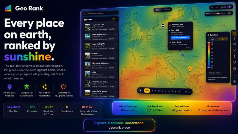
GeoRank is a free, no-signup interactive map designed to end the scattered research process of deciding where to relocate or spend an extended stay abroad. Instead of juggling a dozen open tabs for weather, cost of living, visa rules, and nomad forums that never communicate with each other, GeoRank layers nine comprehensive data sets over a global grid with approximately five-kilometer resolution. The tool is built for digital nomads, remote workers, expats, and anyone evaluating a potential move by providing a single decision-making platform. It combines calibrated sunshine and temperature data from 182 ground stations, tax rates from OECD, PwC, and KPMG sources, per-passport visa and residency routes across 47 destinations for 10 different passports, cost of living data from 478 cities, geopolitical risk assessments, and a community-sourced Nomad Pulse sentiment indicator. Users can pin up to 20 candidate locations, switch to Compare mode to see every metric as a delta against their current home, and ask an integrated AI assistant that reasons exclusively over their own shortlist. GeoRank transforms raw data into a grounded, comparative exploration tool focused on the actual decision of where to live next, not just browsing abstract numbers.
Features of GeoRank
Nine Interactive Map Layers
GeoRank provides nine live data layers that users can toggle on and off, stack together, or explore individually. These layers include sunshine hours calibrated from SARAH-3 satellite observations and ERA5 reanalysis, temperature data, rainfall patterns, outdoor hours, tax rates, visa and residency pathways, cost of living from 478 cities, geopolitical risk assessments, and Nomad Pulse community sentiment. Each layer is sourced from authoritative databases and ground-truthed against real-world stations, ensuring accuracy down to approximately five-kilometer cells across 190 countries. Users can pan globally, zoom into specific regions, and click any location to see detailed source information and methodology for each layer.
Pin and Compare Mode
Users can click any location on the map to pin it to their personal shortlist, with support for up to 20 saved places that persist across browsing sessions. The Compare mode transforms this shortlist by allowing users to set their current home as a baseline. Every metric for every pinned location is then displayed as a delta relative to home, answering questions like how many more sunshine hours a place offers, how much cheaper or more expensive it is, how the tax burden differs, and how geopolitical risk compares. This relative view turns abstract global data into personally meaningful comparisons tied to the user's current reality.
AI Assistant Grounded in Your Shortlist
GeoRank features an AI chat assistant that operates exclusively on the user's pinned locations and their associated metrics, not on a generic knowledge base. Users can ask questions like "Which of my five places has the best winter?" or "Score my shortlist by sunshine, cost, and low tax combined" and receive cited, grounded answers that reason across all pinned locations in a single response. The AI understands every metric for every place and can explain tradeoffs, rank locations by combined criteria, and provide source citations from the underlying data layers, making complex multi-factor comparisons accessible and transparent.
Community-Driven Nomad Pulse
The Nomad Pulse layer tracks weekly sentiment from the digital nomad community by processing social posts into rising, stable, or falling signals per country and city. This community-sourced data provides a real-time indicator of where enthusiasm is building or waning, offering insights that official statistics cannot capture. Users can see shifts in community sentiment before they become widely reported, helping them identify emerging destinations or avoid areas where satisfaction is declining. This layer adds a human, experiential dimension to the quantitative data sets.
Use Cases of GeoRank
Comparing Two Potential Relocation Destinations
A freelancer on a UK passport is deciding between Tbilisi and Paphos for a long-term stay. Using GeoRank, they pin both locations and set their home as the baseline. The Compare mode immediately shows that Paphos offers 3,140 sunshine hours per year while Tbilisi provides only 1,987, which falls short of their 2,800-hour threshold. The tax comparison reveals both locations offer zero percent income tax on foreign-sourced or non-dom income, but the cost of living in Tbilisi is approximately 900 dollars per month versus 1,600 dollars in Paphos. The visa layer shows the UK passport allows 360 days visa-free in Tbilisi versus 90 out of 180 days in Paphos. The AI assistant synthesizes these tradeoffs in a single response with source citations.
Evaluating Multiple Locations for a Winter Base
A remote worker wants to find the best winter location among five pinned candidates. Instead of manually comparing temperature and sunshine data across spreadsheets, they ask the GeoRank AI assistant, "Which of my pinned places is best for a winter base?" The AI reasons across all five locations, considering winter-specific metrics like average temperature, sunshine hours, and outdoor hours during winter months. It provides a ranked answer with specific data points and explains the tradeoffs between warmer, sunnier locations and those with lower costs or better visa conditions, all cited back to the underlying data layers.
Family Relocation Decision with Multiple Criteria
A family considering relocation to three different cities needs to evaluate them across several dimensions simultaneously. Using GeoRank, they pin all three cities and ask the AI, "What are the tradeoffs between these locations for a family?" The AI considers cost of living, geopolitical risk, sunshine hours for outdoor activities, tax implications for dual-income households, and visa pathways for the entire family. It provides a comparative analysis showing which city offers the best balance of safety, affordability, and quality of life, with specific numbers and source citations for each metric.
Identifying Emerging Destinations Before They Become Popular
A digital nomad looking for the next undiscovered location uses GeoRank's Nomad Pulse layer to identify countries and cities where community sentiment is rising. They toggle the Nomad Pulse layer on the global map and see signals color-coded by trend direction. After identifying several rising locations, they pin them and use the other data layers to verify sunshine hours, cost of living, tax rates, and visa conditions. This workflow combines community intelligence with objective data to find promising destinations that may not yet appear in mainstream nomad guides or forums.
Frequently Asked Questions
How does GeoRank calibrate its sunshine and temperature data?
GeoRank merges satellite observations from SARAH-3 with ERA5 reanalysis data, then bias-corrects this information against 182 ground stations worldwide, including locations like Reykjavik, Phoenix, and Sydney. The calibration includes orographic terrain corrections to account for how mountains and coastal features affect local weather patterns. This process ensures that raw satellite data, which often overestimates sunshine in cloudy regions, is adjusted to match real-world measurements. Accuracy is approximately plus or minus eight percent for most locations, though high-altitude areas may see plus or minus fifteen percent variance and coastal microclimates around plus or minus twenty percent.
Is there any cost or signup required to use GeoRank?
GeoRank is completely free and requires no signup or account creation to use. All nine data layers, the pin and compare functionality, and the AI chat assistant are accessible without any payment or registration. Users can start exploring the global map, toggling layers, pinning locations, and asking questions immediately upon opening the website. The tool is designed to remove barriers to relocation research, making comprehensive data accessible to anyone considering a move abroad.
How does the AI assistant know about my specific locations?
The AI assistant operates exclusively on the locations you have pinned on the map, not on a generic knowledge base or internet search. When you pin locations, GeoRank records all associated metrics for those specific coordinates, including sunshine hours, temperature, cost of living, tax rates, visa conditions, and geopolitical risk. When you ask a question, the AI reasons only across these pinned locations and their data, providing answers that are grounded in your personal shortlist. This ensures responses are relevant, specific, and cited back to the exact data layers used for each location.
Can I save my pinned locations between sessions?
Yes, GeoRank saves your pinned locations across browsing sessions, so you can return to your research without losing your shortlist. The tool supports up to 20 pinned locations at a time, allowing you to build a comprehensive set of candidates for comparison. This persistence means you can explore the map, pin interesting locations, close the browser, and come back later to continue your analysis with the same shortlist intact, making long-term relocation research practical and efficient.
Pricing of GeoRank
GeoRank is completely free to use with no signup required. All features including the interactive map, nine data layers, pin and compare mode, and the AI chat assistant are accessible without any payment or registration. There are no premium tiers, subscription plans, or hidden costs. The tool is designed to be an open resource for anyone researching relocation or extended stays abroad.
Similar to GeoRank

AIPetGen
AIPetGen turns a photo of your dog, cat, or other pet, or a written description, into a new picture or a short animation.

Orlyn
Privacy-first, cookieless analytics that connects website traffic to real revenue. Sub-1KB script, no cookie banners.

AUTOMATER.ai
A tray helper for every AI coding tool: one searchable library of past sessions, waiting alerts and usage across 9 providers.

GetYouTubeTranscript
Free YouTube transcripts on the web, a Chrome extension, and an API + MCP server so AI assistants can read YouTube.


